
In the small urban satellite town of Mosgiel, just down the motorway from Dunedin, you’ll find the home base of a GPS system called ‘TracMap’. True to the tradition of kiwi innovation, it is an invention that started small and has gone on to revolutionize predator eradication on islands and difficult landscapes around the world. But to begin with, it wasn’t even intended for conservation work.
Back in 2005, TracMap founding director, Colin Brown first saw GPS systems used to track vehicles. With his background as one of New Zealand’s leading agricultural consultants, he immediately saw it could have applications for fertilizer spreading and so he initially developed TracMap for fertilizer trucks working in New Zealand hill country.
Using TracMap meant that trucks could drive accurately with 18m spacing so that there were no gaps in fertilizer application and no overlap. It made a huge difference, improving efficiency through wider spacing and more even spreading.
For agricultural exporters and food processing companies facing increasingly stringent documentation requirements from the likes of the EU, TracMap also provided ‘Proof of Placement’ that what was applied was done so at the correct rate and sustainably. Producers had the all-important traceability to prove their environmental responsibility.
The first commercial TracMap units were released in October 2006. By October 2009, half the fertilizer spread in New Zealand was applied using the TracMap system.
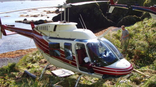
Colin credits another Mosgiel-based businessman for kick-starting TracMap’s move into conservation work. Graeme Gale, managing director and chief pilot of Helicopters Otago approached Colin with a problem. There was no GPS guidance system that suited aerial toxic work on a large scale. Could the TracMap system be adapted for use in helicopters?
That was back in 2008. Since then, TracMap has been used in island eradications and other conservation work around the world – work that has also frequently involved our own world-class helicopter pilots – people like Graeme Gale and Wanaka-based Peter Garden.
When rats were eradicated from infamous ‘Rat Island’ and another 30 islands in Alaska’s Aleutian Islands chain, TracMap was onboard the helicopters to map and control toxin drops with incredible accuracy.
“Operations like that involve thousands of hectares, there’s a huge amount of data,” explains Colin. “Other GPS systems just clog up.”
When you’re carrying out a huge, expensive operation at a remote location, the culmination of years of planning, reliability is essential. You simply can’t afford to have GPS problems. TracMap is reliable and robust.
“The Aleutians eradication established TracMap on the world stage as the product to use for aerial toxic work on islands,” says Colin. “The biggest job has been South Georgia. That took three years with three return visits. It’s a very big Island with rough weather so there weren’t enough flying days to do it all in one year. There are big glaciers going all the way down to the sea form a natural barrier to rats, so South Georgia was subdivided into sections based on those glaciers.”
More recently, TracMap was also an essential tool in the Million Dollar Mouse eradication operation on our own Antipodes Island and it is regularly used for accurate aerial toxin applications across mainland New Zealand. So how does it work?
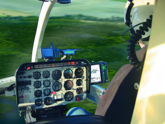
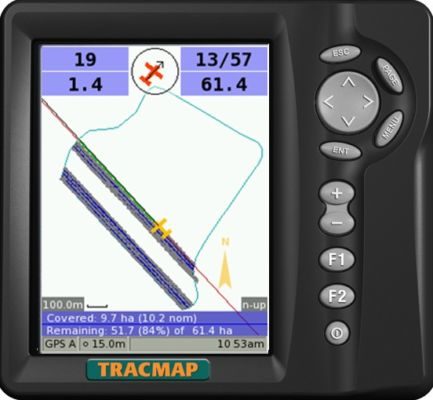
“It’s a lot like mowing a lawn,” explains Colin. “What the pilot sees is the map polygon being painted in.”
The New Zealand-built system has been designed to cope with helicopter applications on hill country terrain. It can cope with large areas, exclusion zones (such as waterways) and irregular boundaries. Most overseas systems, by contrast, have been designed for small areas of agricultural work – fixed wing aircraft fertiliser applications to flat, rectangular fields on the likes of the Kansas plain. It’s a critical difference.
Typically, the block to be treated will have already been mapped by the agency involved (eg Department of Conservation). The GPS map polygon information, including the exclusion zones, is then loaded into the helicopter’s TracMap system which is connected to the on/off autoboom of the applicator bucket.
Spreading will only occur if a number of requirements are met:
• the pilot has switched the spread switch on;
• TracMap detects that the helicopter is inside the application zone AND
• the helicopter is outside any exclusion zones (eg a stream within the application area which has been tagged for exclusion);
• it is not over any previous coverage (so rate of application is very accurately controlled);
• the helicopter is within 4m of the designated flight zone (no gaps in application);
• the helicopter is travelling faster than 15 knots (this is a safety feature, so that if there is an incident that means the helicopter is hovering and the pilot’s attention is engaged, application is automatically stopped until the incident is sorted);
If there is no GPS fix, the system also shuts off.
“It’s impossible to have a wrong application,” says Colin.
If the operation doesn’t match the preplan in some way, there is also flexibility for pilots to add ‘spot exclusion zones’ on the day. If the pilot sees an unmapped picnic area in their flyover recce, for example, they can mark it on their onboard TracMap as an extra exclusion zone, then land the helicopter, transfer the information onto USB stick and share it with the TracMap systems of other helicopters involved in the operation.
Pilots can also modify the software to programme in a buffer zone – eg 100m on all flight lines – so that application automatically shuts off 100m from the polygon boundary. The pilot then finishes ‘painting in’ the map polygon freehand, flying around the boundary to cover the ends. It can be useful to allow for factors such as wind encountered on the day.
“No other system has the ability for a buffer to be set,” says Colin.
Colin describes a demonstration day about a year ago where representatives of regional councils, acclimatisation organisations and animal health boards were invited to see how the system works.
“A large paddock was mapped and divided into three sections: an application zone/exclusion zone/application zone. People could see the helicopter with TracMap automatically shut off over the exclusion zone. Then they walked out to find the bait. No-one found any bait in the exclusion zone.”
It illustrated the very precise placement and rate of application when toxic bait is being applied. The actual levels of application are also very low. There is, perhaps, a tendency to visualise toxic bait applications as looking like a topdressing plane coating the landscape in toxin instead of fertiliser. In reality the picture is very different. When those at the demonstration searched for bait, they struggled to find any in the application zone – even though they saw it clearly being applied. Bait applications are very sparse.
TracMap is a key tool in our battle to save the birds and make New Zealand predator free – and it also has potential in saving human lives. Search and rescue is one possibility for product development in a future.
TracMap is already installed in rescue helicopters in some regions, including Auckland and Otago (where Graeme Gale is chief rescue pilot). It can be used in search and rescue work mapping the search grid over rough seas, making sure that no spot is missed. It also allows points of interest in the water to be GPS marked for closer searching.
It’s an area that Colin has not yet fully pursued. It’s fair to say, the last ten years have already been pretty busy. For an idea first sparked in Mosgiel, the future is looking bright.